Set Heading Points

This forum has been developed to discuss aviation related topics.

Moderators: sky's the limit, sepia, Sulako, lilfssister, North Shore, I WAS Birddog

iflyforpie
Top Poster
Top Poster
Posts: 8132
Joined: Tue Apr 15, 2008 12:25 pm
Location: Winterfell...

Re: Set Heading Points

Post by iflyforpie »

Cat Driver wrote:Back to drift lines.....

Like I said already I have never ever drawn drift lines on any map..ever.

Does that make me an incompetent pilot?
UNCLEAN!!! :lol:

The flight school I worked at tried to get rid of the use drift lines, but TC wouldn't allow it... :roll:
---------- ADS -----------
 
Geez did I say that....? Or just think it....?
User avatar
Janszoon
Rank 2
Rank 2
Posts: 76
Joined: Thu Mar 05, 2009 7:27 pm

Re: Set Heading Points

Post by Janszoon »

Image

Image

Enjoy your map reading. Really, are there only recreational, southern, day VFR flyers on this site?

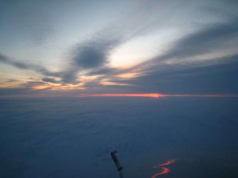
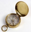
Map reading has merit but it is not always useful. If your GPS fails and you find yourself over the arctic in the winter,
you now have a useless compass and nothing to look at below you. Navaids are few, so perhaps star reading and
using an astrocompass might be a more useful skill. Why aren't students learning that nowadays?

Can you pick out a constellation and use that to navigate in a general direction to get you closer to a navaid? Should
we all learn that skill and is that something we should practice on a regular basis? I'm sure it has helped a few
people in the past.

I agree with learning these skills when obtaining a licence to instill a better understanding of navigation in general,
but in everyday practice these tools are not used, especially drawing lines on your map like drift lines, SHP's, NM
markings, etc.

Sure, there are many bush guys who use map reading skills, myself included. When I'm given a map by a customer
with a dot on it and told "I wanna go there", it's my job to find that spot. When I"m in the arctic tundra in the
winter and looking for a particular lake or river amongst all the white, it becomes VERY difficult but it can be done.

Map reading is a skill you should possess as a pilot, like the ability to add and subtract, or to read and write... well
maybe not write, as grammar/spelling is too hard for most.

We all learned how to match one shape to another before we even reached kindergarten, so it should be
something we have some practice with.
---------- ADS -----------
 
172PIC
Rank 3
Rank 3
Posts: 118
Joined: Sat Jan 09, 2010 6:58 pm

Re: Set Heading Points

Post by 172PIC »

I was taught dead reckoning, SHP's, drift lines and all of that for my PPL that I just got in February. What I was never taught, except a short look during an intro flight was how to use a GPS. This doesn't make a whole lot of sense to me since I'm sure a good portion of real world navigating is done by GPS, especially in commercial operations. It's important to learn the basic navigation skills as it teaches you all the background info, and it's something you can fall back on, but I think it's equally important to learn how to use the technology.

I have my Garmin 296 with me on every flight, I look at the map as often as I do the GPS but I don't bother with SHP's or drift lines, I just draw a single line from airport to airport then plug the route into an online flight planner (does the same math faster) - it's easy enough to get on course once clear of the airport just with the map - just find where it crosses a prominent road or river, and I found drift lines just made the map a mess and obscured the things I was trying to navigate by. I understand the principle of opening and closing drift angles but unless I'm way off course I'd just as soon scoot back up to my planned track and continue from there - besides the technique assumes the wind will be constant the whole route which doesn't seem to happen too often.

Either way in my experience it seems we are too obsessed with the old way of doing things and completely ignore the benefits of GPS and teaching students how to utilize them - a balance of both is the way to go.
---------- ADS -----------
 
User avatar
IBPilot
Rank 3
Rank 3
Posts: 136
Joined: Fri Mar 19, 2010 10:41 am
Location: The Canadian Flatlands

Re: Set Heading Points

Post by IBPilot »

172PIC wrote: What I was never taught, except a short look during an intro flight was how to use a GPS. This doesn't make a whole lot of sense to me since I'm sure a good portion of real world navigating is done by GPS, especially in commercial operations.
The teaching of GPS navigation for PPL is not wide spread. I have friends who went to another flying school from what I went to and I was taught GPS extensively (only because mu FLT Instructor felt that I should know). My other friends just know where the ON button is... most of the aircraft at their flying school are in absence of such technology as well... so especially for PPL, that kind of technology is selective...
---------- ADS -----------
 
Give me a mile of highway and I'll show you a mile; give me a mile of runway, and I'll show you the world!
User avatar
Cat Driver
Top Poster
Top Poster
Posts: 18921
Joined: Sun Feb 15, 2004 8:31 pm

Re: Set Heading Points

Post by Cat Driver »

Either way in my experience it seems we are too obsessed with the old way of doing things and completely ignore the benefits of GPS and teaching students how to utilize them - a balance of both is the way to go.
And who is responsible for that being the norm?
---------- ADS -----------
 
The hardest thing about flying is knowing when to say no


After over a half a century of flying no one ever died because of my decision not to fly.
User avatar
Dust Devil
Rank 11
Rank 11
Posts: 4027
Joined: Fri Jun 24, 2005 10:55 am
Location: Riderville

Re: Set Heading Points

Post by Dust Devil »

172PIC wrote: I found drift lines just made the map a mess and obscured the things I was trying to navigate by.
There is something to be said for lines obscuring relevant information on a chart.

http://www.timesonline.co.uk/tol/news/u ... 063174.ece
She said: “He believes that due to the surrounding information he simply misread 132m as 732m. It was only later that he realised the plot officer had drawn the sub’s new transit straight through the pinnacle, which made it even harder for it to be seen.
---------- ADS -----------
 
//=S=//


A parent's only as good as their dumbest kid. If one wins a Nobel Prize but the other gets robbed by a hooker, you failed
peters
Rank 0
Rank 0
Posts: 4
Joined: Sun Mar 21, 2010 7:52 am

Re: Set Heading Points

Post by peters »

I guess after two pages of sidetracking I can come to the assumption that if you are using drift lines, then you have to use a set heading point. There was never any form of navigation being taught that used drift lines without a set heading point.

It sounds like TC incorporated constant heading navigation using drift lines and set heading points relatively recently though with the amount of people on here saying that they never used them. Were they put in place in the 70's, 80's, 90's??? For those of you who never learned this method, when did you receive your initial training? I think you can skip answering this one Cat as they were probably still inventing compasses when you went through flight school. :wink:
---------- ADS -----------
 
User avatar
FlaplessDork
Rank 7
Rank 7
Posts: 605
Joined: Sun May 25, 2008 9:50 am
Location: British Columbia

Re: Set Heading Points

Post by FlaplessDork »

Off topic, but related.

An exercise I have my students do was dead reckoning under the hood, set their heading, power, etc then put the hood on after their checkpoint and heading correction to see how accurate your headings and times are. I make them finish their double track correction under the hood. I pull the hood off at their time and see how accurate they are. Done right typically they can be right overhead and on time. The not so accurate ones at least are in the vicinity.
---------- ADS -----------
 
flyinthebug
Rank (9)
Rank (9)
Posts: 1689
Joined: Wed Feb 18, 2004 8:36 am
Location: CYPA

Re: Set Heading Points

Post by flyinthebug »

peters wrote:I guess after two pages of sidetracking I can come to the assumption that if you are using drift lines, then you have to use a set heading point. There was never any form of navigation being taught that used drift lines without a set heading point.

It sounds like TC incorporated constant heading navigation using drift lines and set heading points relatively recently though with the amount of people on here saying that they never used them. Were they put in place in the 70's, 80's, 90's??? For those of you who never learned this method, when did you receive your initial training? I think you can skip answering this one Cat as they were probably still inventing compasses when you went through flight school. :wink:
Did my PPL in mid 80s and CPL mid 90s. Both required a flight plan, and a charted flight path with drift lines on the VNC for the flight test. It was included in both my PPL and CPL groundschools. Map reading was a specific topic and we studied it in depth. To this day, I have it listed on my resume as "advanced aerial map reading skills" (perhaps becoming an archiac skill). GPS was just starting to catch on when I did my CPL, so we received little training initially on them. I got my 1st real GPS training with my 2nd employer. The last time I drew drift lines on a VNC was for my CPL flight test (planned cross country).

Fly safe all.
---------- ADS -----------
 
172PIC
Rank 3
Rank 3
Posts: 118
Joined: Sat Jan 09, 2010 6:58 pm

Re: Set Heading Points

Post by 172PIC »

peters wrote:I guess after two pages of sidetracking I can come to the assumption that if you are using drift lines, then you have to use a set heading point. There was never any form of navigation being taught that used drift lines without a set heading point.

It sounds like TC incorporated constant heading navigation using drift lines and set heading points relatively recently though with the amount of people on here saying that they never used them. Were they put in place in the 70's, 80's, 90's??? For those of you who never learned this method, when did you receive your initial training? I think you can skip answering this one Cat as they were probably still inventing compasses when you went through flight school. :wink:
Not sure I entirely get what you are asking - you can use drift lines for any course from whatever points it's drawn between. You don't need a Set Heading Point to use drift lines if you use the airport itself as the initial waypoint (take off, climb to 2000 AGL or higher then cross over the airport on the proper heading instead of using a landmark a few miles away).
---------- ADS -----------
 
cyxe
Rank 3
Rank 3
Posts: 193
Joined: Sat Feb 28, 2004 10:19 pm
Location: The Flatlands

Re: Set Heading Points

Post by cyxe »

peters wrote:I guess after two pages of sidetracking....
Oh the irony....

8)
---------- ADS -----------
 
Why do something now when you can do it later??
into the blue
Rank 4
Rank 4
Posts: 239
Joined: Fri Feb 05, 2010 10:54 pm

Re: Set Heading Points

Post by into the blue »

Drift lines work great for me if I fly an aircraft that doesn't have a GPS. However, their purpose is defeated if:
a) they originate from a point that is NOT your SHP, whatever you choose it be;
b) wind velocity is not likely to be uniform during the course of the leg: for example, as during a flight at a low altitude AGL or a flight in the vicinity of an area of low pressure;
c) you plan or decide to change your cruising altitude during a leg of the flight (of course wind velocity varies with altitude);
d) you fly over an area of open water (even if you stay well within the gliding distance to the shoreline, the lines are useless; I have seen a lot of student pilots draw them anyway).

Also... Though I know traditional methods of navigation are largely forgotten these days, has anyone here used a great technique called "deliberate offset". I learnt it from land orienteering, but no doubt it can be used in certain cases as a back-up to GPS in low-level/marginal VFR flying. The only requirements are a relatively flat terrain en route and a destination close to some LONG, more or less straight landmark that cannot be easily confused (i.e. a highway in a region where there are not a lot of roads, a railway line, a powerline, a pipeline, even an easily-distinguished river may work). The idea is to fly a heading that in most wind conditions will bring you to that geographical feature described above AND off to the right or to the left of your intended destination (you choose which side). A 15-degree offset angle is usually enough to ensure success, unless the crosswind is especially strong. Once you cross that geographical feature, all you have to do now is to turn in the proper direction parallel to that feature and follow it to the destination. This technique can add several minutes to the flight, if compared to the usual "direct to" method but, if done correctly, it practically eliminates the possibility of missing the destination.
---------- ADS -----------
 
Doc
Top Poster
Top Poster
Posts: 9241
Joined: Mon Feb 16, 2004 6:28 am

Re: Set Heading Points

Post by Doc »

When I used to fly VFR in southern Ontario and the States, I carried a Rand McNally Road Atlas, and a map of Barbados on the back of my Mont Gay Rum shirt.
---------- ADS -----------
 
loopa
Rank (9)
Rank (9)
Posts: 1500
Joined: Fri Apr 24, 2009 11:57 am

Re: Set Heading Points

Post by loopa »

I flew from CYVR - KSJC in for my long xc and and I had a GPS as a secondary unit, and the sectionals as a primary navigational reference. PNR.

Learning to read a map is the way to do it.

As far as SHP goes, I don't know, I was taught the SHP method. It doesn't necessarily have to be a point on the map, any visual reference that you can use as a realistic point to start your navigational exercise, do it.
---------- ADS -----------
 
Doc
Top Poster
Top Poster
Posts: 9241
Joined: Mon Feb 16, 2004 6:28 am

Re: Set Heading Points

Post by Doc »

loopa wrote:I flew from CYVR - KSJC in for my long xc and and I had a GPS as a secondary unit, and the sectionals as a primary navigational reference. PNR.
GPS as a "secondary unit..." Why?

Met this old sailor (true story) who, sails across the "big pond" from England to Canada every year. He was just over 70. I asked him if he uses traditional nav, sextants and the like. He said...."HELL NO...I have three GPS's....."
---------- ADS -----------
 
beaverbob
Rank 7
Rank 7
Posts: 722
Joined: Thu Feb 21, 2008 9:34 pm
Location: BC

Re: Set Heading Points

Post by beaverbob »

For lines on a map, I just fold the map so the crease extends from the point of departure to the destination. The crease is my line. Thats all I do. For direction I head to the first large landmark on the map and check the compass. For distance, my thumb from from nuckle to the end is ten statute miles. This method gets me to my destination every time and within 5 minutes of my ETA.
BB
---------- ADS -----------
 
Raybanman
Rank 4
Rank 4
Posts: 266
Joined: Tue Jul 05, 2005 3:05 pm
Location: Not in Florida Damnit

Re: Set Heading Points

Post by Raybanman »

peters wrote:Has there ever been a time where a Set Heading Point didn't exist for planning cross countries? I had someone mention that he was never taught this when he took his licence, yet they still used drift lines. I don't understand how drift lines would tell you how much correction you need to apply to your drift if you never began your planned heading over the point that the drift lines originated at. Is there an old school way of planning a cross crounty that isn't used anymore?
In '97 I was taught to use a set heading point. Used a landmark that was easy to spot ie) highway intersection and started the drift lines from there. After I finished my licenses I never used drift lines again. I drew a straight line between departure and destination (if any line at all) and used map reading.
---------- ADS -----------
 
Some people are like slinkies: Not much good for anything, but they still bring a smile to your face when you push them down a flight of stairs.
loopa
Rank (9)
Rank (9)
Posts: 1500
Joined: Fri Apr 24, 2009 11:57 am

Re: Set Heading Points

Post by loopa »

Doc wrote:
loopa wrote:I flew from CYVR - KSJC in for my long xc and and I had a GPS as a secondary unit, and the sectionals as a primary navigational reference. PNR.
GPS as a "secondary unit..." Why?

Met this old sailor (true story) who, sails across the "big pond" from England to Canada every year. He was just over 70. I asked him if he uses traditional nav, sextants and the like. He said...."HELL NO...I have three GPS's....."
Why not? I wasn't using it as a primary? I had all the maps and I was at all times aware of where I was. I don't think having a GPS to back up that information is a bad thing, if anything, it improves situational awareness. It's like asking a pilot why they turn on the terrain feature on their ND when they have the MOCA and MEA stated on their charts...

What do you think about that? :?:
---------- ADS -----------
 
Big Pistons Forever
Top Poster
Top Poster
Posts: 5956
Joined: Wed Feb 18, 2004 7:17 pm
Location: West Coast

Re: Set Heading Points

Post by Big Pistons Forever »

loopa wrote:
Doc wrote:
loopa wrote:I flew from CYVR - KSJC in for my long xc and and I had a GPS as a secondary unit, and the sectionals as a primary navigational reference. PNR.
GPS as a "secondary unit..." Why?

Met this old sailor (true story) who, sails across the "big pond" from England to Canada every year. He was just over 70. I asked him if he uses traditional nav, sextants and the like. He said...."HELL NO...I have three GPS's....."
Why not? I wasn't using it as a primary? I had all the maps and I was at all times aware of where I was. I don't think having a GPS to back up that information is a bad thing, if anything, it improves situational awareness. It's like asking a pilot why they turn on the terrain feature on their ND when they have the MOCA and MEA stated on their charts...

What do you think about that? :?:

GPS will always give you the most accurate position and navigation information, that is why it should be the primary means of navigation backed up with map and other radios aids. Why deliberately deprive yourself of the best available information ?
---------- ADS -----------
 
icewa
Rank 1
Rank 1
Posts: 33
Joined: Wed Feb 17, 2010 5:16 pm
Location: Dreaming

Re: Set Heading Points

Post by icewa »

I was taught with drift lines and a SHP somewhere close by, I rarely did it over the airport.

Then when i started building time I used the Low airways on the VNC. Turns out those VNC maps have lines pre-drawn on there for you, what a concept.

Then if anything fails you should know roughly whereabouts on the airway you are and look outside the window.
---------- ADS -----------
 
Airplanes
peters
Rank 0
Rank 0
Posts: 4
Joined: Sun Mar 21, 2010 7:52 am

Re: Set Heading Points

Post by peters »

Just to be clear, I'm not arguing the validity of the constant bearing, set heading point, drift-line type navigation in the real world. I also wasn't asking how the set heading point works. I was simply wondering about the possibility of another form of navigation existing with a constant bearing and drift lines but no set heading point. Turns out this doesn't exist.
172PIC wrote: Not sure I entirely get what you are asking - you can use drift lines for any course from whatever points it's drawn between. You don't need a Set Heading Point to use drift lines if you use the airport itself as the initial waypoint (take off, climb to 2000 AGL or higher then cross over the airport on the proper heading instead of using a landmark a few miles away).
172PIC, you're confusing your terminology here. If you use the airport as the initial waypoint, the airport becomes your set heading point. Your set heading point is your initial waypoint regardless of whether or not it's 10nm from the field or overhead the field.
---------- ADS -----------
 
User avatar
x-wind
Rank 7
Rank 7
Posts: 739
Joined: Sat Mar 26, 2005 10:23 pm
Location: Around

Re: Set Heading Points

Post by x-wind »

Do you know why a constant speed and heading are required for the drift lines and time calculations to work? This is the important part.

If you know the principles of dead reckoning you can be as creative as you want. But, 'never make it more complicated than it needs to be'.
---------- ADS -----------
 
loopa
Rank (9)
Rank (9)
Posts: 1500
Joined: Fri Apr 24, 2009 11:57 am

Re: Set Heading Points

Post by loopa »

Big Pistons Forever wrote:
GPS will always give you the most accurate position and navigation information, that is why it should be the primary means of navigation backed up with map and other radios aids. Why deliberately deprive yourself of the best available information ?
BPF, I am in total agreement with you. But for instance when I'm following the I-5, this isn't depicted on the GPS. Wouldn't it be better to use the chart and then back the info up on the GPS as a secondary?
---------- ADS -----------
 
User avatar
Shiny Side Up
Top Poster
Top Poster
Posts: 5335
Joined: Tue Feb 17, 2004 5:02 pm
Location: Group W bench

Re: Set Heading Points

Post by Shiny Side Up »

Cat Driver wrote:Back in the days I owned a flight school I had an early morning flight to drop off a couple of people at Seatac to catch a flight somewhere.

When I walked into the office two of my instructors were just starting to plan a cross country with two PPL students.

I flight filed an IFR flight plan took off climbed to FL210 landed at Seatac dropped off the passengers grabbed a clearance back to Nanaimo landed put the Turbo Commander back in the hangar and went back to my office and these instructors were still flight planning their X/countries.

Amazing.
That might not be a failing of your instructors, but a failing of the students. Nav training I always find is very painful with most PPL students because many here take for granted that they have the ability to read a map. Sounds pretty basic doesn't it? Not so much so. I will say that your average PPL candidate usually doesn't have this basic skill. Many also don't have a clue about stuff like rulers and protractors and some have a real tough time wrapping their head around the idea of there being two different types of miles - especially some of the younger ones who perhaps weren't exposed to the old measurements. With the advent of car-born GPS sets many people rapidly have discarded the basic map reading skills.

I realise that I may have had a very advantageous childhood in this regard as I learned very early on how to use a map to navigate - the best fish after all are where most people aren't adventurous enough to find them.

I should mention as well that many city dwelling people also have trouble determining direction in terms of the basics of NESW and instead often think in terms of rights and lefts - something which doesn't help much when it comes to finding way on a larger and faster scale.

I never have really understood why your average person doesn't cultivate this sort of skill which to me seems so useful for everyday life.
---------- ADS -----------
 
We can't stop here! This is BAT country!
loopa
Rank (9)
Rank (9)
Posts: 1500
Joined: Fri Apr 24, 2009 11:57 am

Re: Set Heading Points

Post by loopa »

Shiny Side Up wrote:
Cat Driver wrote:Back in the days I owned a flight school I had an early morning flight to drop off a couple of people at Seatac to catch a flight somewhere.

When I walked into the office two of my instructors were just starting to plan a cross country with two PPL students.

I flight filed an IFR flight plan took off climbed to FL210 landed at Seatac dropped off the passengers grabbed a clearance back to Nanaimo landed put the Turbo Commander back in the hangar and went back to my office and these instructors were still flight planning their X/countries.

Amazing.
That might not be a failing of your instructors, but a failing of the students. Nav training I always find is very painful with most PPL students because many here take for granted that they have the ability to read a map. Sounds pretty basic doesn't it? Not so much so. I will say that your average PPL candidate usually doesn't have this basic skill. Many also don't have a clue about stuff like rulers and protractors and some have a real tough time wrapping their head around the idea of there being two different types of miles - especially some of the younger ones who perhaps weren't exposed to the old measurements. With the advent of car-born GPS sets many people rapidly have discarded the basic map reading skills.

I realise that I may have had a very advantageous childhood in this regard as I learned very early on how to use a map to navigate - the best fish after all are where most people aren't adventurous enough to find them.

I should mention as well that many city dwelling people also have trouble determining direction in terms of the basics of NESW and instead often think in terms of rights and lefts - something which doesn't help much when it comes to finding way on a larger and faster scale.

I never have really understood why your average person doesn't cultivate this sort of skill which to me seems so useful for everyday life.
You pretty much summed it up right there Shiny 8)
---------- ADS -----------
 
Post Reply

Return to “General Comments”