Time of year for weather radar..
Moderators: lilfssister, North Shore, sky's the limit, sepia, Sulako, I WAS Birddog

Time of year for weather radar..
So getting into that time of year of weather deviations and such. Just wondering what everyone here does in terms of tilt set-up and any neat tricks/formulas you have used/use.

Re: Time of year for weather radar..
I've always paid attention to what Dave Gwinn had to say.....
http://www.bluecoat.org/reports/Gwinn_99_Radar.html
http://www.bluecoat.org/reports/Gwinn_99_Radar.html
-
Changes in Latitudes
- Rank 10

- Posts: 2396
- Joined: Sat Jan 26, 2008 8:47 am
- Location: The weather is here, I wish you were beautiful.
Re: Time of year for weather radar..
Archie Trammell's video, although 20 years old, and pretty dry, was the best educator I had on the subject.
Some of his knowledge is contained in this article:
http://www.aviationweek.com/aw/generic/ ... 310p15.xml
Some of his knowledge is contained in this article:
http://www.aviationweek.com/aw/generic/ ... 310p15.xml
Re: Time of year for weather radar..
Just aim for the really dark area. Always the most entertaining!

Re: Time of year for weather radar..
I made this handout a few years ago plagiarized from Trammell and other sources. It is meant for an 8 degree dish (almost all non-airline aircraft).
WEATHER RADAR, FOR IDIOTS
Our beam is theoretically 8º high and it sweeps 45º either side of 12 o’clock.
Our beam is stabilized, which means that it should stay at the same angle with regards to the earth, no matter what angle our aircraft is at. Unfortunately there are many errors with stabilizing systems and the angles printed on the tilt controller are not always consistent or accurate.
To convert degrees to feet at a particular distance, the formula is:
DISTANCE X 100 = FEET PER DEGREE
(eg. at 10 nm, 1 degree is 1,000 feet)
The fundamental beam positions are:
Threat Identification Procedure or TIP. (excuse the crappy picture)
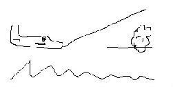
We need to set up our radar so that the bottom of the beam is parallel to the earth. This means that anything shown on the radar will be at or above our altitude. So how do find the TIP? Easy.
If the beam is 8º and the zero position is accurate, just tilt to +4º.
Anything shown should now be at or above our current altitude.
Unfortunately many radars tilts are not calibrated accurately, so here is how to do it:
First, adjust the tilt control until the bottom edge of the beam is sweeping along the ground on the 20-nm arc
You can easily identify where the bottom of the beam intersects the earth. From the bottom of the beam outward the radar indicator will be filled solid with a band of returns all across the swept sector; from the bottom of the beam inward the radar indicator will be blank.
Next, divide your altitude in thousands of feet agl by two. Finally, note the tilt setting with the bottom of the beam sweeping on the 20-nm arc, then increase tilt by a number of degrees equal to the calculation. (Example: You are at 12,000 feet agl; 12 divided by two equals six. With the bottom of your beam sweeping on the 20-nm arc, the tilt index is at minus four degrees, let's say. If so, raise tilt to a setting of plus two degrees-minus four plus six equals a positive two and the bottom of your beam is now sweeping an area from 12,000 feet agl upward. Anything depicted on your radar indicator is an object with a height greater than 12,000 feet agl.)
The Height Evaluation Procedure, or HEP. Once a contouring return is found, we should evaluate it’s height to determine the threat level. How do we determine the height of a return? Easy.
Start in the TIP position (+4º).
Note the distance to the echo of interest.
Raise the tilt until the echo becomes so weak that you can barely see it.
Multiply the difference in tilt by the distance in nm by 100.
Add the result to our current altitude.
Confused?
If we were at 10,000 ft, 23 nm from a cell of interest and had to raise the tilt by 7º to find the top, we would take 23 x 7 x 100 = 16,100 feet, plus our current altitude, 10,000 ft, equals 26,100 ft. Not a bad sized storm. Storms exceeding 30,000 ft should be avoided. Radar tops above the freezing level signify large amounts of water at subfreezing temperatures. Hail is the result. Any time the radar tops exceed the freezing level by 10,000 ft or more, damaglng size hail will be encountered in the area.
If that is too hard for you, use the Tilt Up Technique, or TUT.
Set the tilt to +10º
That’s it. Easy. Now what do we do with the information presented?
Well, by using a bit of math learned earlier, we would realize that with the radar in the TUT position, any returns at 30 nm must indicate a storm that is at least 30,000 ft higher than us, 20 nm indicates a storm at least 20,000 ft above us, etc.
In the terminal area, any storm with radar echoes above 20,000 ft is a potential killer.
Any echo that contours at 10º tilt is a no go when operating below 15,000 ft.
Three absolute life and death rules for the terminal area with 10º tilt are:
Any echo that first appears at 20 nm or greater – whether contouring or not – must be avoided.
Any echo that contours must be avoided, no matter how tall it is.
If the gear is down and a contouring echo is within 5 nm, immediately execute the missed approach.
On departure, simply don’t go.
The Surface Analysis Procedure, or SAP, is an underused but extremely useful technique.
Select the 50, 25 or 10 nm range as the runway nears and set the tilt to -4º.
Easy. Now what can we do with SAP?
We can now use our math skills to determine the height of terrain in relation to our aircraft. At 10,000 ft AGL the ground should give a return at 25 nm (10,000 ft / 4º =2,500 / 100 = 25). At 5,000 ft the ground should be near the 12 nm arc, and at 1,500 ft it should be at about the 4 nm arc. Any echo within the 10 nm arc should command your undivided attention. You are less than 4,000 ft above the target. At 5 nm you are within 2,000 ft of the target.
We can familiarize ourselves with the ground targets at frequently used airports. This is a good navigational backup. It also helps us to recognize storm cells. Picking out a CB from a tank farm is a difficult job.
Most importantly, we can enhance radar shadows. Shadows that appear in TIP may not be very obvious. In SAP they will jump out at you. Here are two radar images of the same cell (yes, more shitty drawings).
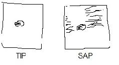
Do you notice that the radar shadow is not apparent in the picture to the left, but on the picture to the right, with the missing ground returns, it is quite easy to realize that there is a radar shadow? This works well on the 50 nm scale.
Remember, radar shadows are caused by a weather system so dense that radar energy cannot penetrate it. The rule is, never, never, ever continue towards a radar shadow. Evidence is abundant that airplanes cannot fly through weather that casts a shadow.
Fortunately we don’t encounter many thunderstorms in this part of the world. Unfortunately, this can leave us at a loss when they do decide to show up. I am no expert at dealing with CB’s either, and without a doubt, my radar skills deteriorate with lack of use. If we all practice these techniques, hopefully they will become second nature and one day pull our asses out of the fire.
Specific Rules
Perhaps the most specific thunderstorm avoidance policy is the one used by Southwest Airlines. Southwest pilots train to the precipitation reflectivity that is presented on their airborne weather radar, and the Southwest guidance is based on these radar echoes. Note that in warmer weather (0º C or above) pilots must maintain at least a 5 nautical mile (NM) separation from all echoes. This minimum separation distance increases to 20 NM if the airplane is not going to clear the cloud top by more than 5,000 feet. Moreover, when flying above 23,000 feet, all weather radar echoes must be avoided by at least 20 NM.
The minimum separation distances in Southwest's thunderstorm avoidance policy have two primary purposes: they not only predispose crews to stay well clear, the policies provide time for flightcrews to keep their options open. As was attributed to the late Gen. George S. Patton, "Weather's not important until it's important, and then it's too late."
'Extreme Avoidance' Thunderstorm Avoidance Guidelines
* When the temperature at flight level is 0º Celsius or higher, avoid all echoes (on the weather radar) by 5 nautical miles.
* When the temperature at flight level is less than 0ºCelsius, avoid all echoes by 10 nautical miles.
* Avoid all echoes by 20 nautical miles if the aircraft clears the tops (of the thunderclouds, as shown on the radar) by less than 5,000 feet. All weather with radar tops above 15,000 feet may be hazardous.
* All weather with radar tops above 20,000 feet is hazardous.
* When flying above 23,000 feet, avoid all echoes by 20 nautical miles.
* Never fly near an echo with a radar top above 30,000 feet.
* If possible circumnavigate echoes by flying on the up wind side.
* Circumnavigate all echoes with steep or asymmetrical gradients.
* Assume that all magenta radar returns are severe thunderstorms.
* NEVER assume that ATC will provide warning of hazardous weather.
* NEVER assume that a PIREP will provide warning of hazardous weather.
* NEVER continue flight toward a radar shadow.
* Note: Although a general or severe thunderstorm may have a well defined base, hazards often exist from the ground to the base of the convective cell, even in VMC.
WEATHER RADAR, FOR IDIOTS
Our beam is theoretically 8º high and it sweeps 45º either side of 12 o’clock.
Our beam is stabilized, which means that it should stay at the same angle with regards to the earth, no matter what angle our aircraft is at. Unfortunately there are many errors with stabilizing systems and the angles printed on the tilt controller are not always consistent or accurate.
To convert degrees to feet at a particular distance, the formula is:
DISTANCE X 100 = FEET PER DEGREE
(eg. at 10 nm, 1 degree is 1,000 feet)
The fundamental beam positions are:
Threat Identification Procedure or TIP. (excuse the crappy picture)
We need to set up our radar so that the bottom of the beam is parallel to the earth. This means that anything shown on the radar will be at or above our altitude. So how do find the TIP? Easy.
If the beam is 8º and the zero position is accurate, just tilt to +4º.
Anything shown should now be at or above our current altitude.
Unfortunately many radars tilts are not calibrated accurately, so here is how to do it:
First, adjust the tilt control until the bottom edge of the beam is sweeping along the ground on the 20-nm arc
You can easily identify where the bottom of the beam intersects the earth. From the bottom of the beam outward the radar indicator will be filled solid with a band of returns all across the swept sector; from the bottom of the beam inward the radar indicator will be blank.
Next, divide your altitude in thousands of feet agl by two. Finally, note the tilt setting with the bottom of the beam sweeping on the 20-nm arc, then increase tilt by a number of degrees equal to the calculation. (Example: You are at 12,000 feet agl; 12 divided by two equals six. With the bottom of your beam sweeping on the 20-nm arc, the tilt index is at minus four degrees, let's say. If so, raise tilt to a setting of plus two degrees-minus four plus six equals a positive two and the bottom of your beam is now sweeping an area from 12,000 feet agl upward. Anything depicted on your radar indicator is an object with a height greater than 12,000 feet agl.)
The Height Evaluation Procedure, or HEP. Once a contouring return is found, we should evaluate it’s height to determine the threat level. How do we determine the height of a return? Easy.
Start in the TIP position (+4º).
Note the distance to the echo of interest.
Raise the tilt until the echo becomes so weak that you can barely see it.
Multiply the difference in tilt by the distance in nm by 100.
Add the result to our current altitude.
Confused?
If we were at 10,000 ft, 23 nm from a cell of interest and had to raise the tilt by 7º to find the top, we would take 23 x 7 x 100 = 16,100 feet, plus our current altitude, 10,000 ft, equals 26,100 ft. Not a bad sized storm. Storms exceeding 30,000 ft should be avoided. Radar tops above the freezing level signify large amounts of water at subfreezing temperatures. Hail is the result. Any time the radar tops exceed the freezing level by 10,000 ft or more, damaglng size hail will be encountered in the area.
If that is too hard for you, use the Tilt Up Technique, or TUT.
Set the tilt to +10º
That’s it. Easy. Now what do we do with the information presented?
Well, by using a bit of math learned earlier, we would realize that with the radar in the TUT position, any returns at 30 nm must indicate a storm that is at least 30,000 ft higher than us, 20 nm indicates a storm at least 20,000 ft above us, etc.
In the terminal area, any storm with radar echoes above 20,000 ft is a potential killer.
Any echo that contours at 10º tilt is a no go when operating below 15,000 ft.
Three absolute life and death rules for the terminal area with 10º tilt are:
Any echo that first appears at 20 nm or greater – whether contouring or not – must be avoided.
Any echo that contours must be avoided, no matter how tall it is.
If the gear is down and a contouring echo is within 5 nm, immediately execute the missed approach.
On departure, simply don’t go.
The Surface Analysis Procedure, or SAP, is an underused but extremely useful technique.
Select the 50, 25 or 10 nm range as the runway nears and set the tilt to -4º.
Easy. Now what can we do with SAP?
We can now use our math skills to determine the height of terrain in relation to our aircraft. At 10,000 ft AGL the ground should give a return at 25 nm (10,000 ft / 4º =2,500 / 100 = 25). At 5,000 ft the ground should be near the 12 nm arc, and at 1,500 ft it should be at about the 4 nm arc. Any echo within the 10 nm arc should command your undivided attention. You are less than 4,000 ft above the target. At 5 nm you are within 2,000 ft of the target.
We can familiarize ourselves with the ground targets at frequently used airports. This is a good navigational backup. It also helps us to recognize storm cells. Picking out a CB from a tank farm is a difficult job.
Most importantly, we can enhance radar shadows. Shadows that appear in TIP may not be very obvious. In SAP they will jump out at you. Here are two radar images of the same cell (yes, more shitty drawings).
Do you notice that the radar shadow is not apparent in the picture to the left, but on the picture to the right, with the missing ground returns, it is quite easy to realize that there is a radar shadow? This works well on the 50 nm scale.
Remember, radar shadows are caused by a weather system so dense that radar energy cannot penetrate it. The rule is, never, never, ever continue towards a radar shadow. Evidence is abundant that airplanes cannot fly through weather that casts a shadow.
Fortunately we don’t encounter many thunderstorms in this part of the world. Unfortunately, this can leave us at a loss when they do decide to show up. I am no expert at dealing with CB’s either, and without a doubt, my radar skills deteriorate with lack of use. If we all practice these techniques, hopefully they will become second nature and one day pull our asses out of the fire.
Specific Rules
Perhaps the most specific thunderstorm avoidance policy is the one used by Southwest Airlines. Southwest pilots train to the precipitation reflectivity that is presented on their airborne weather radar, and the Southwest guidance is based on these radar echoes. Note that in warmer weather (0º C or above) pilots must maintain at least a 5 nautical mile (NM) separation from all echoes. This minimum separation distance increases to 20 NM if the airplane is not going to clear the cloud top by more than 5,000 feet. Moreover, when flying above 23,000 feet, all weather radar echoes must be avoided by at least 20 NM.
The minimum separation distances in Southwest's thunderstorm avoidance policy have two primary purposes: they not only predispose crews to stay well clear, the policies provide time for flightcrews to keep their options open. As was attributed to the late Gen. George S. Patton, "Weather's not important until it's important, and then it's too late."
'Extreme Avoidance' Thunderstorm Avoidance Guidelines
* When the temperature at flight level is 0º Celsius or higher, avoid all echoes (on the weather radar) by 5 nautical miles.
* When the temperature at flight level is less than 0ºCelsius, avoid all echoes by 10 nautical miles.
* Avoid all echoes by 20 nautical miles if the aircraft clears the tops (of the thunderclouds, as shown on the radar) by less than 5,000 feet. All weather with radar tops above 15,000 feet may be hazardous.
* All weather with radar tops above 20,000 feet is hazardous.
* When flying above 23,000 feet, avoid all echoes by 20 nautical miles.
* Never fly near an echo with a radar top above 30,000 feet.
* If possible circumnavigate echoes by flying on the up wind side.
* Circumnavigate all echoes with steep or asymmetrical gradients.
* Assume that all magenta radar returns are severe thunderstorms.
* NEVER assume that ATC will provide warning of hazardous weather.
* NEVER assume that a PIREP will provide warning of hazardous weather.
* NEVER continue flight toward a radar shadow.
* Note: Although a general or severe thunderstorm may have a well defined base, hazards often exist from the ground to the base of the convective cell, even in VMC.
You're not drunk if you can lie on the floor without holding on


Re: Time of year for weather radar..
Great info berzerker. Thanks for posting.
Wx Radar is required equipment for commercial ops with passengers. Is there any requirement that the pilots be trained properly in it's use?
Wx Radar is required equipment for commercial ops with passengers. Is there any requirement that the pilots be trained properly in it's use?
-
rotateandfly

- Rank 5

- Posts: 386
- Joined: Sat Feb 05, 2005 7:53 am
- Location: right here
Re: Time of year for weather radar..
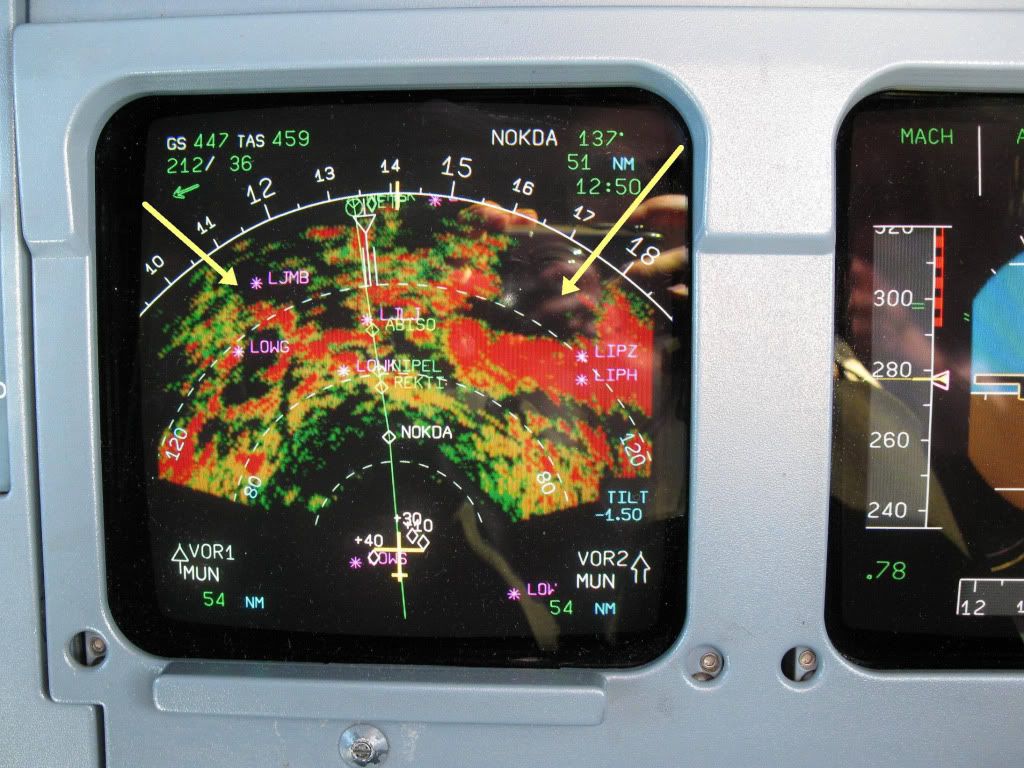
fun fun fun 
- Attachments
-
- wx.JPG (628.93 KiB) Viewed 3266 times
-
Siddley Hawker
- Rank 11

- Posts: 3353
- Joined: Tue Aug 10, 2004 6:56 pm
- Location: 50.13N 66.17W
Re: Time of year for weather radar..
You don't have a whole lot going for ya there. 
-
winds_in_flight_wtf
- Rank 5
- Posts: 372
- Joined: Fri Apr 23, 2010 7:35 pm
Re: Time of year for weather radar..
For those of us who do not have that much experience with WX radar.... please affirm ... the crew driving in the above picture is about to get f***** ?- or ... it was taken in the cockpit of AF 447 just before ......(history)

Re: Time of year for weather radar..
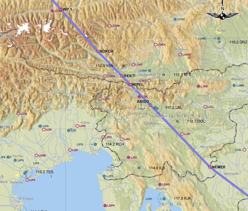
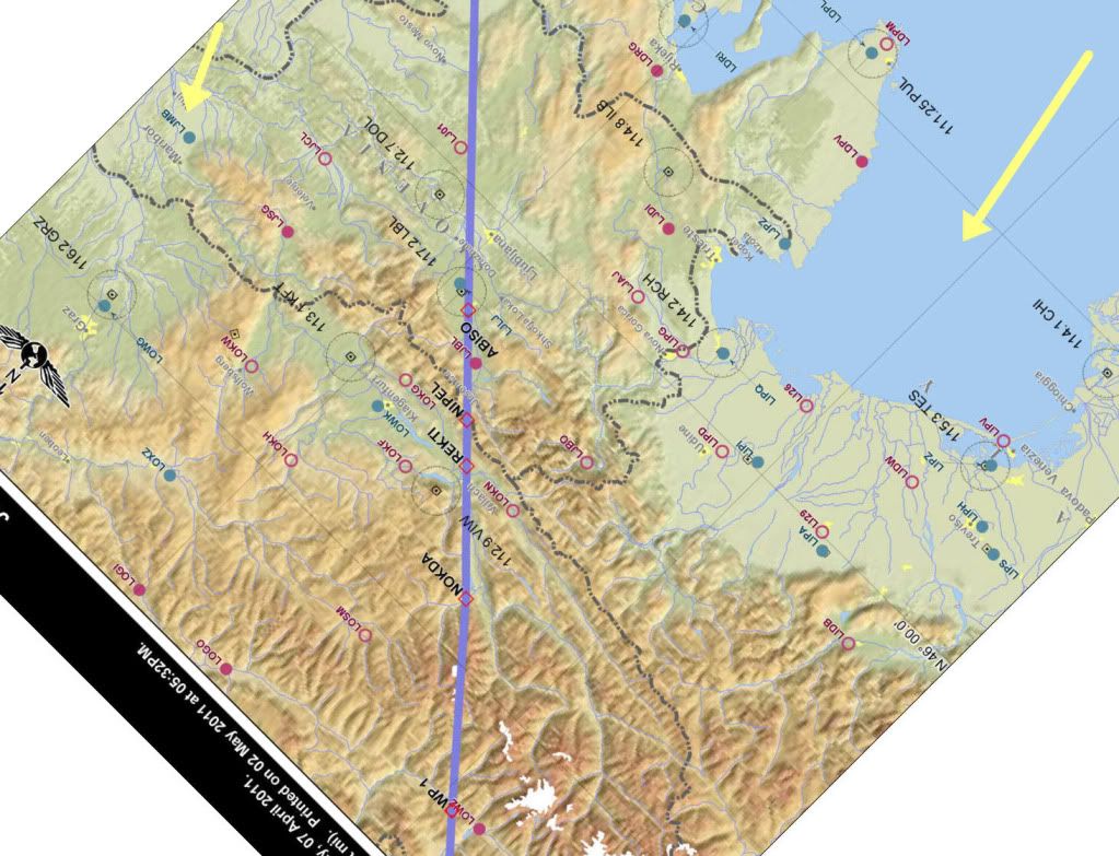
LJLJ is Ljubljana, Slovenia.
Situated next to a mountain range, of course.
I'd guess that at least some of those are ground returns from the rocks...no?
(the ground speed seems to suggest that he's at cruise though, and with only a -1.5 degree tilt down...that could very well be weather)
Situated next to a mountain range, of course.
I'd guess that at least some of those are ground returns from the rocks...no?
(the ground speed seems to suggest that he's at cruise though, and with only a -1.5 degree tilt down...that could very well be weather)
-
Eric Janson
- Rank (9)
")
- Posts: 1409
- Joined: Thu Feb 08, 2007 10:44 am
Re: Time of year for weather radar..
The picture above is showing almost all ground returns. This area is very mountainous.
The only possible weather I can see are a few returns on the left side at 40 and 60 nm.
My Airline operates in the Tropics and thunderstorms are a part of normal operations 12 months a year. The Monsoon is just starting at our home airport. Weather deviations of 60nm are not uncommon especially over India and the Bay of Bengal.
The biggest issue I have had using weather radar is getting any weather to display. Tops in the Tropics can easily reach 45000. There isn't much moisture in these tops and they do not show very well on the radar especially when the thunderstorm is dissipating.
At night or IMC I will set the gain to the MAX position. Tilt at -1 to -1.5 degrees depending on the altitude. Range scale is normally at 40 although I will go to the 80/160 scale periodically to see what is ahead. MAX gain gives a better picture of the edges of the weather as well as the location of the anvils.
It's quite common for nothing to show until 20nm from a top when we get a green return. This gives us just enough time to avoid the top.
On approach the biggest issue is visibility in heavy rain. I've had it happen twice that at 200 feet the rain was so heavy that we couldn't see the runway.
Always fly a stable approach - it's the only stability you'll find in this business
-
rotateandfly
- Rank 5
- Posts: 386
- Joined: Sat Feb 05, 2005 7:53 am
- Location: right here
Re: Time of year for weather radar..
you guys are too smart.
From the middle to the right those are almost all ground returns of the Austrian alps. From the middle to the left actual thunderstorm cells.
From the middle to the right those are almost all ground returns of the Austrian alps. From the middle to the left actual thunderstorm cells.
Re: Time of year for weather radar..
Nice picture.
For the benefit the newbies or those who have never seen a weather radar display, I have included a map of the place this radar is showing. The aircraft is at WP1. (This radar display seems to be ground mapping.)
After the position ABISO, I just extended the line for the sake of argument. I also have tried my best to align the map to the route of flight so you can orientate yourselves better with the radar display, with rather horrendous results.
Reading a weather display involves quite a bit of practice to interpret it correctly. I am guilty of deviating around quite a few islands in the Caribbean at night thinking the return was showing a big CB when it was just showing the island. Likewise, I have crossed the Andes numerous times and thought the red display was just the mountains, until I saw the flashes of lightning.
It is sort of an art form mixed with a little bit of voodoo.
From its TAS and Mach number, this aircraft is at about 30,000 feet (FL300), direction of flight notwithstanding. Notice the range arcs on the display. Each arc is 40 miles. You can see a long way from up there.
On the right, LIPZ is Venice Italy. Just beyond it the display is black, meaning no returns on the radar. That is the Northern tip of the Adriatic Sea.
Over on the left LJMB is in a black area just behind an area of high ground. This would be a low flat area, but you have to be careful with these things because if the aircraft's FMS hadn't put an airport in there, you might assume it was just a low lying area when it could be a radar shadow from the high ground in front, hiding other large rock formations.
Come to think of it, I guess it is more Voodoo than art.
Enough ramblings for now. You get the idea.