INS Question

This forum has been developed to discuss aviation related topics.

Moderators: lilfssister, North Shore, sky's the limit, sepia, Sulako, I WAS Birddog

Post Reply
User avatar
xchox
Rank 5
Rank 5
Posts: 332
Joined: Fri Aug 15, 2008 3:58 pm

INS Question

Post by xchox »

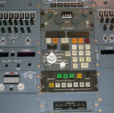
So I've been tinkering with a Delco Carousel INS
Image

Now I know you are supposed to compare distance time with your flight plan for accuracy.

And to improve the accuracy even further, perform a "DME Update".

To this you would have to select an in range VOR/DME. So lets just say you wait till the DME shows 100NM. You would insert the co-ordinates for that VOR/DME into the INS, enter the elevation of the VOR/DME. The distances should be similar between the two. Now the INS would continually update increasing the performance index.

So how was the performance index kept accurate on trans oceanic flights?

Or does an INS only lose accuracy turning way point to way point and would remain accurate on a straight line A-B lat/lon across a long distance?
---------- ADS -----------
 
Meatservo wrote:I just slap 'em in there. I don't even make sure they are lined up properly.
kev994
Rank 2
Rank 2
Posts: 96
Joined: Thu Aug 29, 2013 7:58 am

Re: INS Question

Post by kev994 »

It drifts oceanic. So when you get to the other side you hope that the radar picture resembles what you expect.
---------- ADS -----------
 
ahramin
Rank Moderator
Rank Moderator
Posts: 6317
Joined: Tue Feb 17, 2004 5:21 pm
Location: Vancouver

Re: INS Question

Post by ahramin »

I'm not familiar with that particular INS but in general the INSs themselves do not get updated during a position update. The INS(s) drift constantly no matter what you are doing. Even sitting on the ground they drift. Flying in range of radio stations the Flight Management System will determine its position using both the position of where the INS(s) think they are and the DME distance to nearby stations. The FMS may also incorporate GPS position into its calculation of "where are we". The INS doesn't know about all this though and happily keeps reporting its position with no idea of how far off reality it is.

As long as there are other position sources the FMS happily compares and calculates away and gives you a pretty good position. The more sophisticated units will actually look at the drift of each INS and incorporate that into the position calculation.

On an oceanic flight with no GPS, the FMS only has INS position for many hours. It will still compare multiple INSs but without any external navigation help, the FMS position drifts away from the real position over time. Once you are back in range of radio nav positions the FMS starts correcting the position using that but if it has a large error to start it will take time to get back to something close to actual position. The process can be helped along by doing a position update to tell the FMS: Forget where you thought you were, start calculating as if you are at the inserted position.

The INSs boxes themselves though, by definition, do not get any updates from either the DMEs or the position update and happily keep reporting their drifted position to the FMS throughout the entire flight. It's up to the FMS to sort it all out.
---------- ADS -----------
 
L-1011
Rank 1
Rank 1
Posts: 20
Joined: Tue Dec 03, 2013 9:15 pm

Re: INS Question

Post by L-1011 »

That's the same one on the Sim. I can't even figure out how to turn it on. LOL
---------- ADS -----------
 
Meddler
Rank 3
Rank 3
Posts: 186
Joined: Fri Jan 24, 2014 3:18 pm

Re: INS Question

Post by Meddler »

http://www.aircraftspruce.com/menus/av/ ... armin.html

I think this gps thing may be catching on.
---------- ADS -----------
 
Meatservo
Rank 10
Rank 10
Posts: 2578
Joined: Wed Mar 16, 2005 11:07 pm
Location: Negative sequencial vortex

Re: INS Question

Post by Meatservo »

INS does some things that GPS can't though. It's not just for position information.
---------- ADS -----------
 
If I'd known I was going to live this long, I'd have taken better care of myself
User avatar
Nark
Rank 10
Rank 10
Posts: 2967
Joined: Thu Feb 19, 2004 6:59 pm
Location: LA

Re: INS Question

Post by Nark »

Meddler,

GPS is fine and dandy but...
In the war machine, we use INS as primary source with a GPS overlay for reference. The older model has a dual band GPS that will still work when the U.S. Gov turns off the GPS switch (degrades the signal to something less than 3-10m accuracy).

On the civilian side: we align the IRS (ADIRS) as a matter of powering on the aircraft, we check the nav accuracy before every approach. Parking checklist calls for another check of the IRS "drift."

So long winded way of saying Ariana's is around and very much used.
---------- ADS -----------
 
Qui desiderat pacem, praeparet bellum
Semper Fidelis
“De inimico non loquaris male, sed cogites"-
Do not wish death for your enemy, plan it.
fish4life
Rank 10
Rank 10
Posts: 2552
Joined: Sun Jun 27, 2010 6:32 am

Re: INS Question

Post by fish4life »

What does INS do that GPS can't?
---------- ADS -----------
 
AuxBatOn
Rank 11
Rank 11
Posts: 3283
Joined: Wed Jan 16, 2008 6:13 pm
Location: North America, sometimes

Re: INS Question

Post by AuxBatOn »

Faster update rate, accurately measures accelerations on 3 axis, cannot be jammed/spoofed, self-contained, can update position to name a few...
---------- ADS -----------
 
Going for the deck at corner
kev994
Rank 2
Rank 2
Posts: 96
Joined: Thu Aug 29, 2013 7:58 am

Re: INS Question

Post by kev994 »

Provides an attitude indicator.
---------- ADS -----------
 
fish4life
Rank 10
Rank 10
Posts: 2552
Joined: Sun Jun 27, 2010 6:32 am

Re: INS Question

Post by fish4life »

So it is all part of an aircrafts AHRS?
---------- ADS -----------
 
Meatservo
Rank 10
Rank 10
Posts: 2578
Joined: Wed Mar 16, 2005 11:07 pm
Location: Negative sequencial vortex

Re: INS Question

Post by Meatservo »

It can sense very, very small movements. So small that it can be used to provide attitude and heading information. It "initializes" in one place and from then on, everything it "knows" about where it is it gets from summing all these little movements. Think of it as "dead reckoning" on an infinitesimal scale. The problem is that despite its incredible sensitivity, over time minute errors add up and cause its idea of where it is to "drift". To correct this, it can update its position using VOR/DME information, and now of course GPS information. Another thing that can be done is for the aircraft to have more than one of them so errors can be averaged and hopefully cancel each other out to a certain extent.

It's not "better" than a GPS, but it's better at slightly different things, and like stated above, is self-contained. An aircraft with both is basically able to navigate with incredible accuracy. The GPS is great at being able to tell what direction its antenna is travelling over the surface. The INS can tell which way the plane is pointing down the runway. It can compute crosswinds and direct the autopilot to compensate for them during an automatic landing, just as an example!
---------- ADS -----------
 
If I'd known I was going to live this long, I'd have taken better care of myself
fish4life
Rank 10
Rank 10
Posts: 2552
Joined: Sun Jun 27, 2010 6:32 am

Re: INS Question

Post by fish4life »

Good explanation thanks
---------- ADS -----------
 
goldeneagle
Rank (9)
Rank (9)
Posts: 1301
Joined: Mon Jan 02, 2006 3:28 pm

Re: INS Question

Post by goldeneagle »

fish4life wrote:What does INS do that GPS can't?
It continues to work, when the gps satellites stop transmitting, or cannot be detected due to jamming.
---------- ADS -----------
 
Post Reply

Return to “General Comments”