English words - yes.
English sentence - no.
Moderators: lilfssister, North Shore, sky's the limit, sepia, Sulako

English words - yes.

That makes sense then to retrace the map similar way to pinpoint 'most likely spot" for such nav error potential (as per previous page discussion .. ie "could easily have misssed one of those turns").RookiePilot wrote:and only a relatively minor heading difference, to correct valley
Stallspin wrote: ↑Sat Dec 02, 2017 4:43 pm In that area, with winds comparable to what have been posted here, I've had a lightly loaded sr22 turbo firewalled and still descending at 1500 feet per minute. That experience would have been a lot less fun in a 200hp Mooney.
Does anyone have the ability to post the GFA from that day?
Is that what you're looking for?
I think it's this one:Does anyone have the ability to post the GFA from that day?

Scattered 6-8000 in those mountain passes can easily become a ceiling at a couple of thousand AGL locally in the valleys. Add in the conditions in the hatched area, and what you thought might be a nice VFR day can turn into a really bad trip. I've been through that area a lot, including on a day with nothing worse than SCT forecast when I almost got trapped; the clouds aren't enough to form a real ceiling over the whole area, but when you're in a narrow valley you can't really maneuver laterally to get by them like you could over flat terrain. If you don't leave enough room to turn around, you don't have any choice but to continue forward, and if the vis drops you're in real trouble. I personally won't go VFR through there with any forecast clouds lower than the tops of the mountains anymore, and that GFA looks pretty bad to me.CpnCrunch wrote: ↑Sat Dec 02, 2017 5:59 pmI think it's this one:Does anyone have the ability to post the GFA from that day?
http://gfaarchive.info/gfaDisplay.php?r ... Offset=000
I think PDW and CNPC might have been looking at the wrong day. The plane departed Sat afternoon, but you both were looking at the Sun afternoon weather. The weather actually looks fine from what I can see. The only minor concern is that green hatched area, but it would have been easy enough to see if that had been a problem. Only other concern would be that Lee trough which could indicate strong mountain winds, so I'd want to check the upper winds. I'd also want to check weather at Golden and Revelstoke in case that scattered cloud at 6000ft had gotten any worse than forecast.

Actual weather was scattered at 7000ft ay YRV and YGE. Not sure if there's any weather stations in the passes.
I don't think any of those valleys are particularly narrow, if you stick to the VFR route. I certainly agree that it's a bad idea to go up any narrow valleys in bad weather. Even in good weather it's not a good idea unless you know the area.when you're in a narrow valley you can't really maneuver laterally to get by them like you could over flat terrain.
I'm certainly not suggesting that anyone should go flying in marginal weather in the mountains, and as I said I'd have checked carefully to make sure the hatched area and lee trough weren't an issue before taking off.rookiepilot wrote: ↑Sat Dec 02, 2017 9:07 pm I agree with Diadem. Plus add with that GFA, someone tell me how exactly one is supposed to land in Edmonton? Unless I've misread the map and where I think Edmonton is, looks sketchy.
Trying to fly between those hatched areas....dicey even if clouds remained scattered otherwise.
Checkout the icing and turbulence graph, too.
http://gfaarchive.info/gfaDisplay.php?r ... Offset=000
No thanks for this cowboy. Too much risk.
Let's remind too a chunk of this flight was to be attempted in the Dark. Risk upon risk.
Link seems to work for me, but you can just search for CFESN on flightaware to get it.
You'll need an account with FlightAware to see it since it is a Position-Only Flight and you can only select that option with an account. It can be found under the My Account tab > 6 Position-Only Flights. VFR flights usually only show up if they have ADS-B Out or flight following has been used (i.e. transponder code assigned and entered in the ATC system).
I have it now, thanks. Anybody got the 4 pm MST Metar for Revelstoke that day?Pratt X 3 wrote: ↑Sun Dec 03, 2017 11:25 amYou'll need an account with FlightAware to see it since it is a Position-Only Flight and you can only select that option with an account. It can be found under the My Account tab > 6 Position-Only Flights. VFR flights usually only show up if they have ADS-B Out or flight following has been used (i.e. transponder code assigned and entered in the ATC system).
When this option is activated, you can see additional flights for which FlightAware does not have a filed flight plan.
Tracking data for position-only flights is incomplete and potentially inaccurate.
Sorry, I didn't realise about needing an account on flightaware to see that. I was wondering why it said the flight was hidden, but I could see it (I was logged into flightaware).

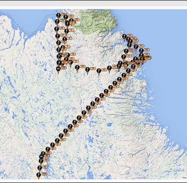
The news stories say they think the most likely location was between Revelstoke and Rogers Pass. That would make sense, as it would be the most likely route they would fly. The cellphone ping at night (if that is correct) seems pretty definitive proof that they crashed in that area and that at least the cellphone survived.Notapilot1 wrote: ↑Mon Dec 04, 2017 11:49 am Hello,
I had tried posting a question earlier but it I am unsure if it went through or if it wasn't approved by a mod for some reason. Anyways, here we go again.
I am seeing a lot of great conversation here about potential location possibilities. Taking all of the environmental factors, plane make and model, experience, weather, etc into consideration is there a consensus as to where they might be? I do have more information if needed, and I feel that the knowledge base here is pertinent to recovery efforts. Experience and pilot train of thought is crucial to the efforts being made (in my opinion.)
SAR is no longer looking and family and friends are relying on public assistance from here on out.
The search team has been overflying the areas where the pilot's cell phone registered a ping to a nearby tower and where their suspected route took them. A flight plan was not filed which exasperates things further. Finding a light GA aircraft in the mountains really is like searching for a 'needle in a haystack'. There are so many visual difficulties that make finding a downed aircraft in the mountains near impossible, especially this time of year with the addition of snow. The rocks are good at hiding things, sometimes forever.Notapilot1 wrote: ↑Mon Dec 04, 2017 11:49 am Hello,
I had tried posting a question earlier but it I am unsure if it went through or if it wasn't approved by a mod for some reason. Anyways, here we go again.
I am seeing a lot of great conversation here about potential location possibilities. Taking all of the environmental factors, plane make and model, experience, weather, etc into consideration is there a consensus as to where they might be? I do have more information if needed, and I feel that the knowledge base here is pertinent to recovery efforts. Experience and pilot train of thought is crucial to the efforts being made (in my opinion.)
SAR is no longer looking and family and friends are relying on public assistance from here on out.
CpnCrunch wrote: ↑Mon Dec 04, 2017 11:38 am Sadly the search is ending if they are not found today:
https://www.castanet.net/news/BC/213157 ... ane-ending
It's certainly an eye opener that we have had 2 planes go down in the mountains this year and we have no idea where they are. ELTs are very unreliable, cellphones can't be relied on, and radar tracking only works if you're up high. Once you're on the ground your plane is virtually invisible under the trees. You really need a SPOT or similar device if flying in remote terrain.
I very much second this, to the point of saying that if a pilot won't equip themselves with this simple, low cost equipment, which would greatly affect the size of search areas, should those large areas be being searched at taxpayer expense. Other jurisdictions are not so giving of search resources.You really need a SPOT or similar device if flying in remote terrain.

|
|
Use AvCanada's information at your own risk!
We reserve the right to remove any messages that we deem unacceptable.
When you post a message, your IP is logged and may be provided to concerned parties where unethical or illegal
behavior is apparent.
All rights reserved.
")